


On Demand Satellite Imagery Access with Maxar SecureWatch
A SecureWatch subscription gives you instant access to the best satellite imagery and geospatial data via web browser or API integration; and you don’t have
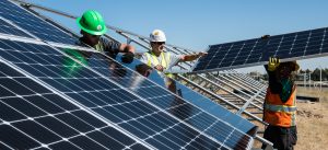
MANAGING SOLAR ENERGY WITH SATELLITE BASED EARTH OBSERVATION
While Russia remains in conflict with Ukraine, and the future of the Russian oil and gas supply is uncertain, the EU is now faced with

Rivers and Lakes are Drying as Europe Faces Worst Drought in 500 Years
According to the report “Drought in Europe” released in July 2022 by the European Commission Joint Research Centre (JRC) Global Drought Observatory, a staggering portion
Satellite vs Aerial Imagery: Which To Use And How To Combine Them
Satellite vs Aerial Imagery: Which To Use And How To Combine Them Remote sensing projects can often begin with the question “Should I use aerial